Just where in the world is Lajitas, Texas you may be
asking. We asked that question ourselves last week as we were travelling to
this destination: up and down hills, around curves, not much evidence of
people, only the occasional few cattle. We did find, though, that there’s so
much history here, and we wanted to share a bit of it with you.
Lajitas is located about 11 miles west of Terlingua,
on the western edge of Big Bend National Park, overlooking the Rio Grande. Lajitas is Spanish for “little flat rocks”
and refers to the Boquillas flagstone found in the area. This region was
inhabited by Mexican Indians for many years, before they were driven from the
area by the Apache and later by the Comanches during the 18th and 19th
centuries. Anglo –Americans first arrived in the mid-1800s.
Quicksilver (mercury) was discovered near Terlingua
in the late 1890s, which brought quite a few people to the area. At the same time
a number of cattle ranches and mining enterprises appeared in the area,
increasing commerce across the Rio Grande into Mexico. Farming along the Rio
Grande brought even more families, and by 1912 the town of Lajitas had a store,
a saloon, a school with 50 students, and a boardinghouse. The crossing into
Mexico, with a smooth rock bottom all the way across the Rio Grande, was the
best crossing between Del Rio and El Paso.
The leading citizen of Lajitas from 1902 to 1917
was a man by the name H.W. McGuirk. He operated the store-saloon, farmed, and
helped manage the nearby Terlingua Mining Company. He also funded the
construction of a church and the school. He petitioned for the establishment of
a post office in town, which operated until 1939 when it closed permanently.
McGuirk’s land was sold many times over the years; one landowner became
successful in the candelilla wax business, The Lajitas Wax Company.
However, all commerce in the area was interrupted in
1916 by the arrival of Pancho Villa and his bandits from Mexico. This brought
General John J. Pershing and his troops to Lajitas, where they established a
major cavalry post.
The Lajitas property continued to change hands over
the years. In 1949 the property was purchased by Rex Ivey, Jr., who hand-dug a
well and installed a generator for the area’s first electric lights. With the
closing of the area’s quicksilver mines the number of residents dropped to just
4. Restoration of the property began when part of the property was sold in 1976
to Walter Mischer from Houston and the Mischer Corporation.
By 1980 Lajitas had become a resort destination with
50 residents and 15 businesses. The old church had been restored; there were 3
motels, a hotel, a restaurant, a golf course, a swimming pool, an RV park, and
an airstrip. The original trading post remained open. In 1990 there were still
50 people in residence here. The Big Bend area was becoming popular as a site
for moviemaking, and at the time the TV miniseries, Streets of Laredo, starring James Garner, was filmed here. By
2,000, the population had grown to 75.
Monday was another beautiful and cloudless day in
Lajitas, Texas, although it started out a bit cool at just 48°. While I
finished the blog, Dick took off on his motorcycle for a 5-hour, 100 mile ride
farther down Highway 170 to Presidio. (I didn’t realize he’d be gone so long,
so was starting to get worried when 5:00 p.m. arrived, but he hadn’t. He did
come rolling in a bit later, thankfully…)
He recounted his ride: the road takes you along the
Rio Grande which, he said, was so close you could almost touch it. There were
magnificent mountains on both sides of the river until you got closer to
Presidio where there were lots of low land farms and ranches closer to the
river. As long as 800 years ago, Native American farmers lived here in
permanent villages, growing corn, beans and squash, as well as conducting
extensive trade. The town of Presidio now has a population of around 5,000, is
right on the border with Mexico, even has a Bealls department store! While in
that area he stopped in at the historic site, Fort Leaton.


Although Fort Leaton was not a military fort, the
U.S Army maintained a presence here. The fort served as a home, trading post
and private fortification for family and visitors, soldiers, traders,
freighters, Native Americans and Anglo settlers alike, against Native American
raids and borderland outlaws.
The current Fort Leaton is a reconstructed
fortification that served as a trading post on the old Chihuahua Trail from
1848 to 1884, when it was known as El Fortin. The fort was occupied until the
mid-1920s when it was abandoned. The State of Texas, following an archeological
survey, erecting monuments at the site, and in 1940 excavations and measured
drawings were done. In 1967 the Texas Parks and Wildlife Department acquired
the site, initiating additional architectural and archeological investigations
before beginning restoration work. The site opened to the public in 1978.
Fort Leaton was constructed of native materials,
including earth, rock and wood. Large, sun-dried adobe bricks for the walls were
laid on rubble stone foundations; the walls range in thickness from 18” to 44”.
Mud mortar was used to set the bricks, then plastered with a mixture similar to
the adobe mud with a lime additive. Interior walls were plastered, too, and
given a heavy coat of whitewash. All door jambs, headers, lintels, sills and
roofing joists were built of hand-hewn cottonwood. The original ceiling joists
were covered with river cane and then packed with up to 18” of adobe mud. The dimensions of the fort are 140' x 200'. Can
you imagine building a structure with 40 rooms plus a patio and
corral, out of adobe?
The patio featured an intricate 40’ water drain
paved with rocks, which is still visible today. Living quarters had double
fireplaces, serving 2 rooms at a time, with a common chimney. A huge fireplace, in what is thought to
have been the kitchen, and according to legend, had the potential to roast a
whole beef, a few goats, and pigs—all at one time (probably not, but the
fireplace was huge!). Other identified rooms were a possible nursery, bakery,
dungeon (where debtors were incarcerated), tack/blacksmith room, and holding
pens for animals. Two of the rooms have been identified as household trash
pits, based on the artifacts excavated here, which included gun cartridges, ink
and other glass bottles, various dishes and tableware, buttons, metal tools,
pipe bowls and ceramic doll heads.
Also on property is a mausoleum, first erected in
the 1920s as a chapel by the original owners.


We spent another day in Big Bend National Park on
Tuesday, this time visiting a dinosaur fossil site, hot springs, some adobe
ruins and Boquillas Canyon. If you’re interested in reading about the history
of Big Bend, here’s a link.
The fossil site in Big Bend boasts one of the
largest fossil finds found anywhere in the world. There’s a glassed-in exhibit
of fossil replicas found here, and we heard there are plans to build a
multi-million dollar facility to house and protect the fossils and the area. We
can’t confirm this, but thought it was interesting. Dinosaur remains from the
last 35 million years have been found here, including over 90 dinosaur species,
nearly 100 plant species, and more than 2 dozen fish, frogs, salamanders,
turtles, crocodiles, lizards, and early mammals. A marine fossil found here is
a 30’ long sea-dwelling reptile, known as Mosasaurus. These finds, and the
possibility of future discoveries, are worth a fortune for paleontologists.

One of the biggest draws to the Big Bend National
Park is the area of Hot Springs near the Langford ruins. A rich history is
preserved here, where petroglyphs are visible on limestone cliffs lining the
Rio Grande. One of the earliest settlers in this area was J.O. Langford, who,
in 1909, heeded the call to “Go West Young Man.” Suffering from malaria that
ravaged his body again and again, this Mississippian wanted to move to an area
where he could regain his health. While in Alpine, Texas he heard an old man
tell tales of a spring that would cure anything: stomach trouble, rheumatism,
all sorts of skin diseases. The old man
said, “Nothing down there but rattlesnakes and bandit Mexicans. And it’s too
far away—that damned country promises more and gives less than any place I ever
saw.” After verifying the story with other townspeople, and without even
looking at the land, Langford knew he had to have that spring. He rushed to the
county surveyor’s office, filed his claim under the Homestead Act, and 2 weeks
later received word that the claim was his. (Others had filed claim to this
land, but no one met the requirements of the Homestead Act: 3 years of
continuous occupancy and $300 in improvements to the land, in addition to a
minimum bid of $1.50 per acre.)
The journey, with his pregnant wife and 18-month old
daughter, to their new home took 11 days (which today takes 2 hours). When they
arrived they discovered Mexican squatters living on and farming their land.
Realizing that this land had probably been home to this family for generations,
they accepted them as neighbors, and let them continue to live there.
Langford regained his health by taking a 21 day
treatment of bathing and drinking the water from the hot springs. He then built
a small motor court, charging just 25 cents per night; he then opened the
spring to others, charging 10 cents per day, or $2.00 for the whole 21 day
treatment. The Hot Springs was more than just a place to restore health; it was
also a meeting place for people from all walks of life, from both sides of the
Rio Grande; it was a prelude to the tourism that would come with the
establishment of Big Bend National Park.
Several of the original buildings have been
preserved in the Hot Springs area. And…you can soak in the 105° water that
bubbles up from a hole in the old foundation of the bathhouse that Langford had
built.
The springs are about ¼ mile from the parking area.
The site, of the Langford ruins, is about 2 miles from the main road and
becomes really narrow and windy, and
one car-width wide through a rough, narrow wash. It was an interesting drive in
the dually!! We didn’t soak in the hot springs, but we did eat our picnic lunch
adjacent to the old trading post.


 Once back on the main road we drove to the Rio
Grande Village and ruins of the Daniels farm house and ranch. The farm house
represents one of the last vestiges of pioneer farming in West Texas. (Most of
the small-scale farms in the Big Bend area fell to ruin after the park was
established in 1944.) The house is a 2-room adobe structure, about 44’ x 15’.
Once back on the main road we drove to the Rio
Grande Village and ruins of the Daniels farm house and ranch. The farm house
represents one of the last vestiges of pioneer farming in West Texas. (Most of
the small-scale farms in the Big Bend area fell to ruin after the park was
established in 1944.) The house is a 2-room adobe structure, about 44’ x 15’.
Our next stop was to Boquillas Canyon, just up the
road. It offers a beautiful vista of the Rio Grande as the river enters the
canyon, and the small village of Boquillas del Carmen across the river. Until
9/11 the border between the U.S. and Mexico allowed people to go between the
two countries as needed. In May 2002 the border crossing from Big Bend to
Boquillas was closed indefinitely, destroying Boquillas del Camen’s traditional
way of life. As of October 2006 only 19 families of around 90 to 100 residents
remained there. Most of the residents were forced to move away by the closure
of the tourists crossing and destruction of the town’s traditional economy.
In the spring of 2013 the border reopened. Crossing
is available Wednesday through Sunday, via horse, donkey, or boat, depending on
the river depth. Since the opening of the border crossing the town of Boquillas
del Carman has seen substantial growth with the addition of electricity (brought
over from the U.S.), a new medical care office, and enhancements at the public
elementary school. A single telephone line now comes into the village. The
village’s population is now said to be about 200 persons.
Although we didn’t go over into Mexico, Mexican
Nationals cross the river by foot, horse/donkey, or boat to sell their wares at
various points in the park, including the Hot Springs area and Boquillas Canyon
overlook.


We spent Wednesday in Lajitas, doing a 2.5 hour walk-about
through the town, where the Comanche Indians once roamed, and Pancho Villa led
raids across the Rio Grande, cowboys sat around an open campfire, and miners
drank whiskey at the Trading Post.
To begin our walk, we passed the Lajitas Cemetery.
Small communities grew up on both sides of the Rio Grande during the late 1800s
and early 1900s. As such, a cemetery was necessary to accommodate those who
passed on. This cemetery was established during that time. Most of the original
wooden crosses have long since weathered away and are no longer readable. A
restoration project was begun in 1991 to place a fence around the cemetery, a gate and
arch leading to this special place, and iron crosses placed on the graves.

Today, Lajitas is a destination resort, offering a first-class golf course, spa, equestrian events, shooting activities, and a first-class restaurant and saloon. Some of the resort rooms are located on the site where General Pershing’s cavalry established their post, overlooking the parade grounds. McGuirk’s home, open for special events, overlooks the Chisos Mountains and Rio Grande; the adjacent trading post (where Pancho Villa used to drink whiskey), is now the Longhorn Museum and golf course pro shop. Quite a few adobe structures are still visible and on-property.


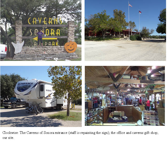
We spent Thursday getting ready to leave; our next destination was Caverns of Sonora in Sonora Texas, where we were headed on Friday. We did have dinner that evening at the Thirsty Goat Saloon at the Lajitas resort: tortilla soup and a wedge salad. YUMMY!
Thursday night we had a strong wind and thunder
storm that blew one of our bicycles out from under our camper. The weather
report said wind gusts at 4 mph could be expected. Ha! It was more like 40 mph!
By 10:00 a.m. on Friday
we were on the road, headed to Sonora. The drive was relatively easy with
occasional rain showers. We were settled within an hour after our arrival at
3:00 p.m. The park is beautiful, with access to the caverns on-property. That
night was a night of heavy rain, thunder and lightning. Wow! We lost power a
few times during the night, but that was OK; we were comfy and dry. There is no
cell service, no WiFi, and no TV at the park. Thank goodness we had our KING
satellite dish! Oh, and they feed deer, so dozens of deer grace the park in the
mornings and at night. They also have 2 pair of peacocks on-site, that you’ll
find resting on the Adirondack chairs on the office/gift shop porch.
Saturday was spent
running errands in the very small town of Sonora, about 15 miles away. The town
was established in 1889, and a few historic buildings still remain—more on this
next week. We tried to find WiFi somewhere. Our only option was at the Comfort
Inn, where they graciously let us take up residence in the lobby for a couple
of hours to catch up on all things internet-related. After doing a bit of
grocery shopping we headed back to the RV park.
We woke Sunday to a
beautiful cloudless day, with cool temps dipping to 47°. It doesn’t take long
for the sun to do its thing and warm things up, so by early afternoon the temps
reached almost 80°. We chose this day to take a tour of the caverns. We were
not disappointed.
The Caverns of Sonora
were discovered around the turn of the 20th Century, when a dog
chased a raccoon into a 20” hole. Local ranch-hands began to explore the cave
sometime in the early ‘20s, but could only go back about 500 feet from the
entrance to a 50’ deep pit. In 1955, Stanley Mayfield, the landowner gave
permission to 4 cavers from Dallas, who discovered a further 7 miles, including
what are now considered the most scenic areas of the cave. Today, 2 miles of
trails through the caves have been developed, from the 7 miles of explored
cave. The cave’s most famous formation was the butterfly. It was the only known
formation like it in the world, formed by 2 fishtail helictite growths that
share the same attachment point of the cave wall.
Our tour was almost an
hour long, going to the depths of 150 feet below ground. Formations throughout
the cave were illuminated to highlight their beauty. The only items we could
take with us were a camera and/or cell phone to take photos. Humidity reached a
high of 80%, but temps were only around 70°. The walk down wasn’t bad, but
those 150 steps and steep walkways on the way back… Whew!


That’s it for this
week. We leave Tuesday, heading for a Corps of Engineers park southeast of
Austin for 10 days before arriving at Rockport, our winter destination. Stay
tuned!
Love ‘n’ hugs,
RJ and Gail
Just for your information, if you're even interested, the Lajitas church was not "restored to it's original appearance."
ReplyDelete