Monday, September 14—my, where does time go? Early last week a wildfire started directly across the road from our campground. These are photos of the fire over 2 days.

We decided to
spend a couple of days exploring Bryce Canyon and surrounding areas. We packed
an overnight bag and lunch for 2 days, and headed out.
On the way we stopped at the Kolob Canyons section of Zion
National Park, which is located in the NW section of the park, accessible from Interstate
Highway I-15. This is definitely one to put on your bucket list. The views of
this 5-mile drive are stunning, with vistas of crimson red canyons that take
your breath away. The narrow parallel box canyons cut into the Colorado
Plateau, forming 2,000’ cliffs and soaring peaks of Navajo sandstone with
cascading falls and streams. (For the avid hiker there is over 20 miles of
hiking trails for you!)
The Kolob Canyon area was first settled by Mormon farmers in
1851 that used the area for timber and grazing cattle, sheep and horses. They
also prospected for mineral deposits. The Mormons named this place Kolob, from Mormon
scripture, which means “the heavenly place, nearest the residence of God.”
It was difficult to select photos, so enjoy these ‘til you
have an opportunity to visit Kolob Canyon for yourselves!


Our next stop was the Cedar Breaks National Monument off
State Route 14. This area is a form of badlands, with canyons, spires (known as
hoo-doos), walls and cliffs so steep that its only value is aesthetic. Early
settlers called this area badlands or “breaks” and their misnaming the junipers
in this area as cedars ultimately gave it its name: Cedar Breaks.
Cedar Breaks is a natural amphitheater, stretching 3 miles
across, with a depth of over 2,000 feet. The rim of the amphitheater is over
10,000 feet above sea level! Although similar to Bryce Canyon, the rock here is
more eroded than at Bryce. And, because of its elevation, the road through the
park is often inaccessible from October through May. Cedar Breaks was
established in 1933, with a small lodge that was deemed uneconomical to operate
by the park service; protests regarding its demolition caused the park service
to reexamine its policies and thus contributing to its preservation and
eventual expansion to what it is today.
Erosion is taking its toll on the canyon: about 2” every 5 years.
The brilliant colors that draw us are created by the iron (reds, oranges and
yellows) and manganese (shades of purple) in various combinations.
Wildlife thrives at this altitude, and includes mule deer,
porcupines, marmots, red squirrels, golden-mantled ground squirrels, pocket
gophers and chipmunks, as well as mountain lions and elk (these are seldom
seen). And, the ravens are HUGE! We saw only squirrels. We would love to see
this area in the spring when wildflowers are in full bloom. The growing season
is quite short, but apparently Colorado Columbine, Scarlet Paintbrush,
Subalpine Larkspur, Shooting Stars, Orange Sneezeweed, Silvery Lupine, Yellow
Evening Primrose, Plantainleaf Buttercups and other varieties cover the canyon
in vivid color.


That evening we spent the night in Parowan, which is
Southern Utah’s first settlement, founded in 1851. The main economic resource
is tourism, as it serves as a year-round gateway to Brian Head Resort for
skiing, and Cedar Breaks National Monument.
Artifacts, including petroglyphs, arrowheads, pottery and
pit houses dating from A.D.750 to 1250, have been found in this area, and are
evidence that Parowan was on a major thoroughfare of early Native Americans,
most probably Fremont and Anasazi Indians. In addition, the Old Spanish Trail
also passed through this area.
Parowan has been called the “Mother Town of the Southwest”
because of the many Mormon pioneers who left from there to start other
communities in southern Utah, Nevada, Arizona, Colorado, Oregon and Wyoming.
We stayed at the Victorian Rose Inn Monday night, a quaint
inn built in 1904 as a single family home. It subsequently became a boarding
house or hotel, and then apartments. More recently it was purchased and
converted into a Victorian Inn, with 5 apartment-like rooms complete with
kitchens. Our “apartment” had 15’ ceilings, a sitting room, full bath, small
kitchen and bedroom. Very comfortable. And…their WiFi was screaming!
Dinner that evening was at La Nueva Villa Mexican restaurant
across the street. Being a “dry” town, no alcohol was available so no
Margaritas, but the food was excellent! We chowed down enchiladas, tacos and
tostados—and tons of chips and salsa!
Breakfast Tuesday morning was at
Parowan Café—food was good but the wait time for it was extremely looooooong.
We ordered almost immediately, but weren’t served for almost 45 minutes. Good
thing we like coffee! Ha!

After breakfast we headed to Bryce Canyon. But to get to
Bryce we had to drive through Red Canyon.
Red Canyon, it is said, is the
inspiration for the term “red rock.” Its formations of colorful limestone
formations made for a photographer’s dream, as you’ll see in the photos below.
Sparse vegetation dots the steep slopes and cliffs of this beautiful area; the
rich green ponderosa pines add a beautiful contrast to the deep red of the
canyon. Seven plant species grow here that are found together nowhere else in
the world. Pretty cool. These plants have adapted to the severe environmental
conditions here that tend to exclude other common species, and are called edaphic, meaning that they are
influenced more by the soil than the climate.


Although Bryce Canyon is called a canyon, it’s actually a
collection of giant natural amphitheaters. As we saw at Cedar Breaks, Bryce is
distinctive due to the “hoodoos” found throughout the park. Bryce sits at a
much higher altitude than Zion, with the rim varying from 8,000 to 9,000 feet,
and all the vistas are visible from these altitudes. We noticed the pressure a
bit, and found breathing to be a bit labored, especially at Bryce Overlook
where we trekked up and down a few paved paths (all for the purpose of
capturing—or trying to capture its beauty on camera).
Bryce Canyon was settled by Mormon pioneers in the 1850s,
and was named after Ebenezer Bryce, who homesteaded in the area in 1874. The
LDS church sent Bryce and his wife Mary to settle land in this area because
they thought his carpentry skills would be useful to other pioneers settling in
the area. They chose to live right below Bryce Canyon Amphitheater, grazing
their cattle inside what are now park borders. He is reputedly to have said
that the amphitheaters were a “helluva place to lose a cow.” He also built a
road to the plateau to retrieve firewood and timber, and a canal to irrigate
his crops and water his animals. Other settlers soon started to call this
unusual place “Bryce’s Canyon,” which was later formalized into Bryce Canyon.
Covering an area of almost 36,000 acres (or 55.992 square
miles), the area around Bryce Canyon became a National Monument in 1923 by
President Warren G. Harding, and designated as a National Park in 1928. The
current Bryce Canyon Lodge was built in 1924-25 of local materials.
Archaeological surveys of the canyon show that people have
been in the area for at least 10,000 years; basket-maker Anasazi artifacts
several thousand years old have been found south of the park and artifacts from
the Pueblo-period Anasazi and Freemont cultures have also been found.
The Paiute Indians, who moved into this area after the other
cultures left, developed a mythology surrounding the hoodoos in Bryce Canyon.
They believed the hoodoos were the Legend People whom the “trickster Coyote”
turned to stone. At least one older Paiute said his culture called the hoodoos
“anka-ku-was-a-wits,” which is Paiute for “red painted faces.”
The Rim Road, which is still in use today and is the scenic
drive atop the plateau we drove, was completed in 1934 by the Civilian
Conservation Corps. The National Park Service implemented a voluntary
summer-only, in-park shuttle service in June 2000, transporting visitors to
each of the scenic overlooks in the park.
For you who are interested, the brown, pink and red colors in
the park are from iron oxide; the yellows from limonite; and the purples from manganese
dioxide. The hoodoos are composed of soft sedimentary rock, topped by a piece
of harder, less easily eroded stone. Bryce Canyon has one of the highest
concentrations of hoodoos of any place on earth.
Due to the elevation, there are 3 distinct life zones in the
park: dwarf forests dominate the lower areas, ponderosa pine forests cover the
mid-elevations, and Douglas fir and white fir make up the forests on the
plateau. It was interesting to learn that the harshest areas of the park have
limber pine and ancient Great basin bristlecone pine thriving, some more than
1,600 years old.
The most common large animals found in the park are the mule
deer—we didn’t see any. Elk and pronghorn deer are also sometimes seen.
However, the forests and meadows of Bryce Canyon support diverse animal life,
from birds and small mammals to foxes and occasional bobcats, cougars and black
bears. In addition, 3 wildlife species currently as endangered species take up
residence in the park: the Utah prairie dog, the California condor, and the
southwestern willow flycatcher. There are about 170 species of birds in the
park, as well as 11 species of reptiles, and 4 species of amphibians.
Unfortunately, while we were in the park, we were hit with strong
gusty winds, rain and cold temperatures (48°); we didn’t plan our wardrobe very
well, as we had donned shorts and t-shirts that morning. Thankfully, we did
have sweatshirts and fleece with us, which helped—a little. Even still, Dick was
able to capture some amazing photos of Bryce. Enjoy.

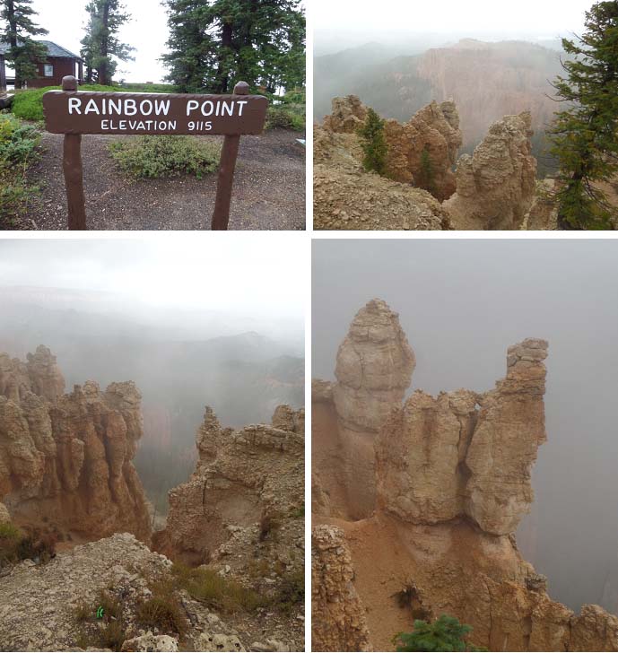
We decided to drive the Rim Road all the way to the end, to Rainbow Point and work our way back to the park entrance. The following photos are in order from that point, with the exception of Ponderosa Canyon--it was too foggy to see anything!


 As we left the Canyons, we turned south to take state route 14
across to Highway I-15. As we drove, we came upon acres of lava beds, which
apparently represent the last of the extensive volcanism in the area.
Geologists believe that some of this lava rock is not more than 2,000 years
old, and that it didn’t come from a central volcano, but rather it welled up
from cracks and fissures in the earth’s surface. We passed Navajo Lake which
was formed when lava flowed across the eastern end of the valley where it’s
located. Lava tubes run under the lake and drain water into both the Great
Basin and Colorado River drainages as the headwaters of the Virgin River (which
subsequently flows through Zion National Park).
As we left the Canyons, we turned south to take state route 14
across to Highway I-15. As we drove, we came upon acres of lava beds, which
apparently represent the last of the extensive volcanism in the area.
Geologists believe that some of this lava rock is not more than 2,000 years
old, and that it didn’t come from a central volcano, but rather it welled up
from cracks and fissures in the earth’s surface. We passed Navajo Lake which
was formed when lava flowed across the eastern end of the valley where it’s
located. Lava tubes run under the lake and drain water into both the Great
Basin and Colorado River drainages as the headwaters of the Virgin River (which
subsequently flows through Zion National Park). We returned to our camper about 5:00 p.m. It sure was a lot
warmer there than at Bryce! We stopped at the office to collect
mail/packages/etc., and to my surprise my husband did not forget it was my
birthday! He handed me an Amazon box containing a dozen long-stemmed red roses
with a dozen Asian lilies! And, now that they’ve all opened, the fragrance is
fabulous and permeates the entire camper! Thanks, Honey! I love you!
We returned to our camper about 5:00 p.m. It sure was a lot
warmer there than at Bryce! We stopped at the office to collect
mail/packages/etc., and to my surprise my husband did not forget it was my
birthday! He handed me an Amazon box containing a dozen long-stemmed red roses
with a dozen Asian lilies! And, now that they’ve all opened, the fragrance is
fabulous and permeates the entire camper! Thanks, Honey! I love you!
Well that was Tuesday.
Wednesday we stayed close to home. Temps hit 86°, which felt
really good after days of near 3-digit temps, and then a day of half that!
Thursday, after I did laundry (a woman’s work is never done!),
we drove a few short miles to the nearby Silver Reef Museum.
The mining town of Silver Reef really flourished between 1876
and 1890. Sadly, now it’s a ghost town with nothing left but crumbling rock
walls and foundations set against a spectacular background of red sandstone
cliffs. Of the original structures, only the 1878 Wells, Fargo & Co.’s
Express building remains intact and houses the museum. An item of interest:
Silver Reef is the only place in North America where silver has been found in
mineable quantities in sandstone. In the 14 years that the town was at its
zenith, over 7 million ounces of silver were taken out of the areas 33 mines.
The museum was interesting too, in that many of that era’s
artifacts, documents and photographs are on display. These include:
·
The
original Wells Fargo vault where the silver bullion was held and protected
until it could be loaded on a stage coach or wagon and hauled 75 miles to the
rail head in Milford, UT;
·
Bottles,
buttons, guns, shoe lasts, Chinese gambling games, carpentry tools, hat pins,
and myriad other items;
·
At
its peak, the town had almost 2,000 residents
from 18 countries and 29 U.S. states (interesting that there were no
Mormons); photographs and documents depict the daily life in this early
frontier mining town;
·
Geologic
samples and information from the mines and the surrounding area;
Adjacent to the museum is the restored Cassidy Powder House,
which was originally used to store dynamite for the nearby mines. It now houses
a diorama of the main part of the old town. We took the interpretive walking
trail to get a better idea of what the town was like. The town included the
Cosmopolitan Restaurant which was reputed to serve the best hash in the
territory. The Harrison House was considered to be Silver Reef’s Waldorf
Astoria with 45 rooms and a 5-star restaurant. There was a printing office, and
a variety of main-street shops. The Elkhorn Saloon which was the site of many gun
fights, one of which involved the owner; the saloon also served as a courtroom.
The Cassidy Powder House, Catholic church, the Rice Bank, mines, schoolhouse
(which has been moved to nearby Leeds and still serves as the Town Hall), and
the Nichols/Lubbock home (the most beautifully built, surrounded by trees and
gardens) were all the landmarks still visible.
 |
| Silver Reef Museum is located in the Wells Fargo and Company Express Building, built in 1877. |
 |
| The Cosmopolitan Restaurant burned but was totally rebuilt and now is the venue for special events. The Elk Horn Saloon is no more, but the sign says it all! Many businesses lined the streets; the bottom 2 photos are ruins of those businesses and the Harrison House Hotel. |
 |
| The ruins of the printing house are still visible; the Cassidy Powder House was rebui.lt and now houses a complete diorama of the town and an audio of the town's history |
 |
| The mine shaft and various other buildings are still visible. A sign for the old school is adjacent to the stone walls that surrounded it. A memorial to St. John's catholic Church stands adjacent to the Rice Bank building. |
Friday was travel day to Cornville, Arizona for a 1-week stay at
Page Springs RV Resort. It was an easy but long day, 320 miles. It did involve
driving up and down mountains (the highest elevation was 8,700’), through high
deserts and canyons, which were beautiful. Along the drive we saw wild horses,
wild turkeys, chipmunks, an Airstream caravan (14 of them!), beautiful Navajo
jewelry at Vermillion Cliffs rest area, and giant boulders at Cliff Dwellers,
AZ. (Oh, and before we left Utah, we saw a giant squished tarantula at our site!)
Gaining an hour, we arrived to our next park at 5:00 p.m. Still
daylight, still warm. Our site is adjacent to a stream running through the
park. The only down side was Dick backed into a neighbor’s pickup, just barely
making a mark, as he was attempting to back our camper into our site. Oh, the
hazards of backing up into a narrow spot, from a not-so-good angle. The park
has 46 sites, and is part of the Sunrise Resorts family. Most of the campers
are here for the weekend only, as there’s a big motorcycle rally in nearby
Cottonwood.

Dinner was nachos here at home. We were so tired…
Saturday dawned with 66° and sunshine. We drove back into
Cottonwood to run some errands and visit the visitor center. Dick hit the Home
Depot and I walked to the visitor center. Wouldn’t you know, it was closed on
weekends of all things. Dang! I did meet
Jade and Thomas from New York City, who were also at the visitor center and
disappointed they were closed. We struck up a conversation; they were very
interested in our full-time RVing and everything that went into preparing for
this life. We talked for almost 20 minutes. Very cool. Hope they stay in touch,
as they sounded like they were ready to hit the road!
Back at the ranch, we spent the afternoon watching football (The Ohio State University 20: Northern
Illinois University 13. (Woot-woot!)
That’s it for this week. Stay tuned for more exciting adventures
in next week’s blog as we share our day trip to Red Rock State Park, Sedona and
other places in the area. Until then,
Hugs ‘n’ love,
RJ and Gail
No comments:
Post a Comment